
Volume estimation using aerial LIDAR
Theory :
LiDAR (Light Detection and Ranging) is a remote sensing technology that uses laser pulses to measure distances and create high-resolution, three-dimensional maps of the environment. It works by emitting a laser beam that bounces off surfaces and returns to a receiver, allowing the system to calculate the distance to the object. LiDAR is used in a wide range of applications, including environmental monitoring, urban planning, forestry, archaeology, surveying, and autonomous navigation. It is particularly useful in situations where accurate and detailed measurements of terrain, vegetation, and structures are needed, and where traditional surveying methods are either impractical or insufficient.
LiDAR works by emitting rapid pulses of laser light and measuring the time it takes for the light to bounce back to the sensor. By recording the time delay and the intensity of the returning light, LiDAR systems can create highly accurate 3D maps of the environment.
There are different types of LiDAR systems, including airborne, terrestrial, and mobile LiDAR, each with its own strengths and weaknesses depending on the specific application.
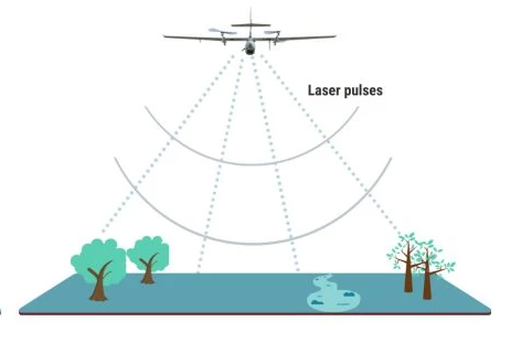
Airborne LiDAR is commonly used for mapping large areas, such as forests or entire cities. It is typically mounted on an aircraft or drone and can cover large areas quickly, generating highly accurate 3D maps of terrain, vegetation, and structures.
Terrestrial LiDAR is used for mapping smaller areas, such as individual buildings or archaeological sites. It is typically mounted on a tripod or vehicle and can capture highly detailed 3D maps of the surrounding environment.
Mobile LiDAR is used for mapping roadways, railways, and other transportation infrastructure. It is typically mounted on a vehicle and can capture highly accurate 3D maps of the surrounding environment at high speeds.
LiDAR has numerous applications across a range of fields, including environmental monitoring, geology, forestry, archaeology, surveying, urban planning, and autonomous navigation. It has revolutionized the way we map and understand our world, allowing us to capture highly accurate and detailed information about the environment in ways that were previously impossible.
- Laser: The LiDAR system emits rapid pulses of laser light, typically in the near-infrared range, with wavelengths of around 900-1600 nm. The laser emits light in short pulses, typically around 10 nanoseconds in duration, and the system can emit thousands of pulses per second
- Scanner: The LiDAR system also includes a scanner that directs the laser beam and collects the returning light. The scanner may use a rotating mirror or a rotating prism to direct the laser beam in a scanning pattern, allowing the system to capture a full 3D map of the environment.
- Detector: The returning light is collected by a detector in the LiDAR system, which measures the time delay and intensity of the returning light. The detector may use a single photon detector or an avalanche photodiode to detect the returning light.
- GPS: To accurately geo-reference the 3D map, the LiDAR system typically includes a GPS receiver that provides accurate positioning information. This allows the LiDAR data to be integrated with other spatial data, such as satellite imagery or topographic maps.
- Data processing: The raw LiDAR data is typically processed using specialized software to generate a high-resolution, 3D map of the environment. The data may be filtered to remove noise or artifacts, and algorithms may be used to classify different types of objects, such as vegetation, buildings, or terrain.
- Accuracy: The accuracy of LiDAR data depends on a range of factors, including the laser pulse rate, the scan rate, the resolution of the detector, and the accuracy of the GPS system. High-end LiDAR systems can achieve centimeter-level accuracy, while lower-end systems may have accuracies in the range of a few meters.
Airborne LiDAR can be used to measure the volume of objects or structures on the ground, such as forests, crops, buildings, or terrain features. This is accomplished by using the LiDAR data to create a high-resolution, three-dimensional map of the environment, which can then be used to calculate the volume of objects or structures.
For example, to measure the volume of a forest, the LiDAR system would generate a 3D map of the forest canopy, capturing the height and shape of individual trees. This data could then be used to calculate the total volume of wood in the forest. Similarly, to measure the volume of crops, the LiDAR system could generate a 3D map of the crops, capturing their height and density, which could be used to calculate their total volume.
To calculate volumes using LiDAR data, various algorithms and software tools are used, which can analyze the 3D data and perform calculations based on the shape, height, and density of objects. These calculations can take into account various factors, such as the size and shape of individual objects, the density of objects, and the presence of other objects in the environment.
Overall, airborne LiDAR is a powerful tool for measuring the volume of objects and structures on the ground, providing accurate and detailed information that can be used for a range of applications, including forestry, agriculture, construction, and mining.
Advantages:
- High accuracy: LiDAR can provide very accurate measurements, with typical accuracy levels in the range of centimeters to a few meters, depending on the system and application. 2.High resolution: LiDAR can provide high-resolution 3D data, allowing for detailed mapping of terrain, buildings, vegetation, and other features.
- Wide coverage: LiDAR can cover large areas quickly and efficiently, making it useful for surveying, mapping, and monitoring applications.
- Day and night operation: LiDAR can operate day and night, making it useful for applications that require 24/7 monitoring.
- Non-contact measurement: LiDAR is a non-contact measurement technique, which means it can be used to measure objects or structures that are difficult or dangerous to reach.
Disadvantages:
- Cost: LiDAR systems can be expensive, with high-end systems costing hundreds of thousands of dollars.
- Limited penetration: LiDAR can only measure objects or structures that are visible from the air or ground, which means it cannot penetrate through solid objects like walls or thick vegetation.
- Weather-dependent: LiDAR can be affected by weather conditions such as fog, rain, and snow, which can reduce its effectiveness.
- Data processing: LiDAR data can be complex and require specialized software and expertise to process and analyze, which can be time-consuming and expensive.
- Limitations in certain environments: LiDAR may not be suitable for certain environments, such as areas with dense vegetation, rough terrain, or very bright sunlight, which can interfere with the laser signal.