
Georeferencing of Toposheet
INTRODUCTION
In other words, georeferencing is the process of associating a digital image file with physical locations. In the field of geographic information systems, the term refers to the process of associating a physical map or raster image of a map with spatial locations. Georeferencing can be used to refer to any object or structure that can be linked to a geographical location, such as points of interest, roads, places, bridges, or buildings. Geographic locations are most commonly represented using a coordinate reference system, which can be associated with a geodetic reference system like WGS-84.
The coordinate system is standardized by EPSG and given with codes. For example, GCS EPSG code is 4326 where as UTM EPSG code for Mangalore is 23643.
Two types of coordinate systems:
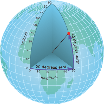
- Geographic Coordinate System: A geographic coordinate system is a three-dimensional reference system that locates points on the Earth's surface. The unit of measure is usually decimal degrees. A point has two coordinate values: latitude and longitude. Latitude and longitude measure angles. Latitude is defined as the angle formed by the intersection of a line perpendicular to the Earth's surface at a point and the plane of the Equator.
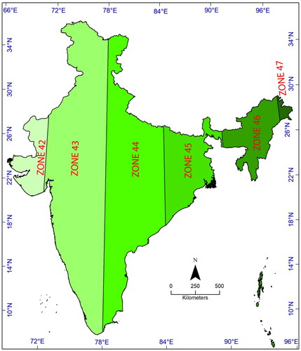
- Projected Coordinate System: Used to locate objects on a flat surface a paper map or a digital GIS map displayed on a flat computer screen. A projected Coordinate System is also called a plane coordinate system built on map projection. To maintain the level of accuracy desired for measurements, a projected coordinate system is often divided into different zones, with each zone defined by a different projection center. India has 6 UTM zones, i.e., zone 42 (far west, Gujarat) to 47 (Far east, Arunachal Pradesh)
For example, establishing the correct position of an aerial photograph on a map, or determining the geographical coordinates of a place name or street address (Geocoding). Image data can be converted to a geographic control framework using GIS tools such as ArcGIS, QGIS or ERDAS Imagine. A set of points, lines, polygons, images, or 3D structures can be georeferenced. For example, a GPS device, will record the latitude and longitude coordinates of a given point of interest, effectively georeferencing that point. A georeference must be a unique identifier. In other words, there can only be one location for which a georeference serves as a reference.
To georeference an image, control points and the known geographic coordinates of the added control points has to be appropriate along with a defined coordinate system and other projection parameters in-order to minimize residuals. The difference in coordinates between both the actual coordinates of the control points and the coordinates predicted by the geographic model created with the control points defines residuals. They provide a method for determining the precision of the georeferencing process. When data is collected and assigned to postal or area codes, it is usually necessary to convert it to geographic coordinates using a definitive directory or gazetteer file. This type of gazetteer is frequently extracted by census agencies, national mapping organizations, or postal service providers. Mangalore taluk of Dakshina Kannada District falls under ND 43-15 mangalore toposheet.
Source: