Definition of Levelling
- Levelling or leveling is a branch of surveying, the object of which is to establish or verify or measure the height of specified points relative to a datum.
- It is widely used in cartography to measure geodetic height, and in construction to measure height differences of construction artifacts.
- Leveling is the general term applied to any of the various processes by which elevations of points or differences in elevation are determined.
Uses of levelling
- To determine or to set the plinth level of a building.
- To decide or set the road, railway, canal or sewage line alignment.
- To determine or set various levels of dams, towers, etc.
- To determine the capacity of a reservoir.
Areas of application
- Design of highways, railroads, canals, etc.
- Layout construction projects according to specific design.
- Calculate earthwork volumes.
- Investigate drainage characteristics.
- Develop maps showing general ground configurations.
- Monitor earth subsidence.
Important terms used in levelling
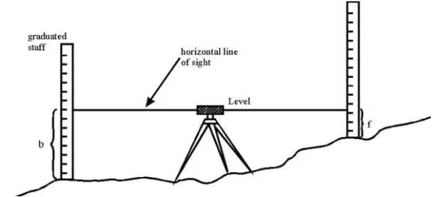
- Vertical line - A line that follows the local direction of gravity as indicated by a plumb line.
- Level surface - A curved surface that, at every point is perpendicular tothe local plumb line (the direction in which gravity acts).
- Level line - A line lying in a level surface is a level line. It is thus a curved line normal to the plumb at all points. In field surveying, it is defined by the direction of a freely suspended plumb-bob.
- Horizontal plane - A plane perpendicular to the local direction of gravity.In plane surveying, it is a plane perpendicular to the local vertical line.
Important terms used in levelling
- Horizontal line - A line in a horizontal plane. In plane surveying, it is a line perpendicular to the local vertical.
- Vertical datum - Any level surface to which elevations are referenced. This is the surface that is arbitrarily assigned an elevation of zero.
- Elevation - The distance measured along a vertical line from a vertical datum to a point or object.
- Benchmark (BM) - A relatively permanent object, natural or artificial, having a marked point whose elevation above or below a reference datum is known or assumed.
Important terms used in levelling
- Height of instrument - It is the elevation of the plane of sight with respect to assumed datum. It is also known as plane of collimation.
- Back sight(BS) - It is the sight taken on the level staff, of a known elevation with the intention to obtain the elevation of plane of collimation. It is called PLUS sight because it is added to elevation of that point to get height of instrument or plane of collimation.
- Intermediate sights(IS) - These are the sight taken after back sight and before sighting the final point. These are called MINUS sights. These are subtracted from plane of collimation to find the reduced level of different points.
Important terms used in levelling
- Fore sight(FS) - The last reading taken from the instrument. This is also a MINUS sight.
- Change point(CP) or turning point(TP) - The point at which both BS and FS are taken.
- Reduced level(RL) - The elevations of the points with respect to assumed datum.
Types of levelling
- Simple levelling.
- Differential levelling.
- Fly levelling.
- Profile levelling.
- Precise levelling.
- Reciprocal levelling.
Types of levelling
1. Simple levelling -
It is a simple and basic form of leveling in which the
leveling instrument is placed between the points which
elevation is to be find. Leveling rods are placed at
that points and sighted them through leveling
instrument. It is performed only when the points are
nearer to each other without any obstacles.
Types of levelling
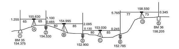
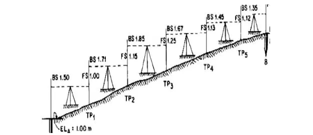
2. Differential levelling -
Differential leveling is performed when the distance
between two points is more. In this process, number of inter
stations are located and instrument is shifted to each station
and observed the elevation of inter station points. Finally
difference between original two points is determined.
Types of levelling
3. Fly levelling -
Differential leveling is performed when the distance
between two points is more. In this process, number of inter
stations are located and instrument is shifted to each station
and observed the elevation of inter station points. Finally
difference between original two points is determined.
Types of levelling
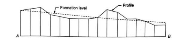
4. Profile
levelling -
Profile leveling is generally adopted to find elevation of
points along a line such as for road, rails or rivers etc. In
this case, readings of intermediate stations are taken and
reduced level of each station is found. From this cross
section of the alignment is drawn.
Types of levelling
5. Precise
levelling -
Precise leveling is similar to differential leveling but in this case higher precise is wanted. To achieve high precise, serious observation procedure is performed. The accuracy of 1 mm per 1 km is achieved.
6. Reciprocal
levelling -
When it is not possible to locate the leveling instrument
in between the inter visible points, reciprocal leveling is
performed. This case appears in case of ponds or rivers
etc. in case of reciprocal leveling, instrument is set
nearer to 1st station and sighted towards 2nd station.